
|
|
|
| Use the text links for more information! |
|
The Romans made Exeter an outpost of their empire, arriving between AD50 and AD60.
Isc is the Celtic word for water, thus the Roman word Isca. The saxon for Isc was Exe, the Roman for camp
was Castra. Hence the modern day name of Exeter. Isca-casra, Iscastra, Exe-castra, Exeter.
An original Roman Fortress
was built at Exeter in AD70 with the City Wall built later around AD200 surrounding
the later Civil Settlement.
The Romans called the road on which it stood the Ickneild Way and on the crest of the hill built a Forum (a public square used for judicial and other business) and a Praetorium (a market place and living quarters for the soldiery). The occupying legion protected the City while the forced Briton labour restored the walls in AD200 and laid tesserae (small square block paving) in pavements at their conquerors' bidding. Initially Publius Anicius (Vespasian's camp prefect) oversaw the construction of a temporary fort above the quay with Poenius Postumus supervising the later larger military fortress. The military presence lasted about three decades with many buildings (of timber) constructed. There was however a stone bath-house built in AD55. Poenius Postumus's failure to respond during Boudicca's rebellion in AD60-61 brought great shame and he eventually killed himself. In AD75 - AD80 the legion dismantled the fortress pallisades and took them to Wales. The soldiers were needed to garrison a fort in Caerleon for Agricola's campaigns in Scotland. The Bath-house was demolished with offices and shops being built in its' place. Public baths were built nearby as Isca Dumnoniorum became the Civitas regional capital. |
|
Britons were eventually integrated into the life of the City with many becoming involved in local government. The
Romano-British town flourished as a trade centre. Free men were full citizens of the Roman Empire. By the C4th the
population of the town had grown to around 3000. Around AD380, the forum was given a facelift but by this time the town
was starting to decline, this was accelerated when the Roman administration withdrew in AD410.
Very little remains of the Roman grid street pattern, the northern part of High Street does however follow roman lines.
As Rome began to decline, their legions were required nearer home. Attila and his Huns were at Rome's gate and eventually the Romans leaving the City to the Britons. |
|
Excavations of the Legionary Bathouse began in 1971. Parts of the hypocaust of the military bath-house and
the later basilica were uncovered. These remains have now been re-covered by sand with a view to later developing
the site as a tourist attraction. However because of it's position on Cathedral Green there will no doubt be endless
debate about how best this can be achieved. The remains apparently are one of the most impressive of their type in Britain!
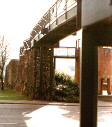
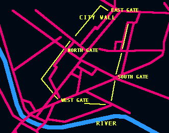
A mosaic pavement was also uncovered in 1989 at a site in St Catherine's Almshouses, Catherine Street. Attila and his Huns were at Rome's gate and eventually the Romans departed leaving the City to the Britons. Until I'd started writing this website I was completely unaware of the scope of what remained from the Roman Occupation, large sections of the wall are still visible in most places, the obvious and possibly best preserved are those stretches in Southernhay and at the bottom of South Street. Around Rougemont Castle is another good site to view the wall though deciding which is Roman and which is Norman is always going to be a problem. Look for the chamfered plinth. The schematic below shows the old path of the Roman wall and the positions of the four gates. A fifth gate was cut through at the Quayside in 1566. This is shown on Hogenburg's map of 1587, it was called Watergate. |
 |