
|
|
|
| Use the text links for more information! |
|
Exit the pub and turn right, head for Exe Bridge.
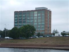
Bonhay Road was commisioned by the Bristol and Exeter Railway Company. The road only originally ran as far as Exe Street. The railway had it extended and named it Prince's Road after Prince Albert. The large green office block on the left is Renslade House and was constructed in 1968. Great care was taken at the time to blend the building into the City profile, the buzz-word at the time being Townscape Awareness. The green and beige facade is an attempt at awareness. Don't drink what these bastards were drinking! As you approach the second bridge, to your left you'll see what is left of an Exe Bridge built in 1238 and also what remains of St Edmund's Church. |
| St Edmund's St Edmunds by the Bridge as it was known, was the original chapel on the first stone bridge built around 1190, it was completely overhauled in 1449. And you're right, those dates don't quite tally up. The Church is dedicated to St Edmund (849-870), the King whose shrine at Bury St Edmunds was very famous all over Europe. This gives rise to the belief that there probably was a church on this site in Saxon times on an original Roman Bridge. The bridge currently seen here passed diagonally from St Thomas and led up to the West Gate of the City by Stepcote Hill. It was about four times longer than the present Exe Bridges, don't forget that the river was much wider and shallower in those days because it was not constrained by man-made banks. The church only became redundant in the 1960's when Western Way was built, it was made safe and left as a memorial of past times. |
 |
| Bridge
The two bridges that you now see crossing the
Exe were completed in 1974, these replaced the former structure opened
in 1905, its old lamp stands can be seen marking the Butts ferry crossing
on the Quay. The pictures in the 'pop up'
show this grand bridge with Gregory's boats beside it. A three arched bridge existed prior to
this one.
Construction was started in 1770, but floods caused extensive
damage and it was not completed until much later. As far as I know you
can still see the stonework of this bridge below the current level of Bridge
Street. The other picture in the sequence is today's bridge.
City Brewery
The first lease to mention the City Brewery appeared in 1801 though the first reference to a brewery in Commercial
Road / Exe Bridge was in a letter from the Mayor (15th Sept 1760) to Richard Densham. Densham went into
partnership with Samuel White to form the brewery. As the business expanded, other partners and their money were
required. By 1823, the company was known as White, Pinney & Dawe of Exe Island.
The company became predatory buying up inns and breweries and in 1789 bought the New Brewery on the other side
of the river. This brewery had the added bonus of it also being a malt-house.
By 1844, the Company was run by Salter & Knowles. Benjamin Salter though eventually sold his interests to John
Norman and by 1845, the company was known as Norman & Co. Salter had previously been involved with the New Brewery.
Walter Pring joined the company in 1865, the company becoming Norman & Pring but it was not until 1911 they
had limited liablity. In 1943, Norman & Pring bought the St Annes Well Brewery Company and it's tied houses.
|
The photo shows the brewery beside the river but there were also bottling plants in Edmund Street and Frog Street which were automated in 1937. Whitbread bought Norman & Pring Ltd. and all their tied houses which amounted to 168 in 1967 immediately combining it with another business, Starkey, Knight & Ford of Tiverton. The City Brewery site was closed only for the building to be badly damaged by fire later that year. The brewery was eventually demolished in 1969/70 for the Western Way road development. The brewery was actually integrated into the structure of the medeival bridge, some of its cellars being the arches of the bridge. 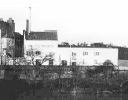 Next up is West Gate before we head off to the. Turn up Western Way and cross the road. On your left you'll see St Mary Steps Church with its fascinating church tower clock, a number of Tudor buildings and the entrance to Stepcote Hill. By now you'll be getting thirsty so I'll hurry. As the clock strikes the hour, the foreman in the middle nods his head and the two creeps beside him sound quarter hours with long hammers at their feet. Matthew Miller's mill was close by. He was extremely punctual and after his death the clock was erected as a memorial to him in 1619. |
 |
 |
| The present church was built in the
15th century but replaced an earlier structure. Just to the right of the
church is Stepcote Hill, which ran into
the City from West Gate at the bottom of the hill, an old Elizabethan Street
well worth a look. The area around here was known as the West Quarter.
Notice the cobbled pavements and the central drain.
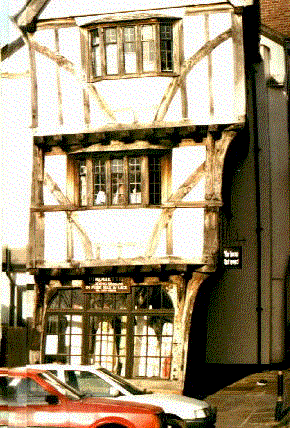
'The house that moved', is that which stands to the left of the church, this fine example of Tudor architecture was saved from demolition in December 1961 when it was moved from its original position in the path of a new road being built to aid traffic flow near the the old Exe Bridge in Frog Street. It was in fact 16 Frog Street. It got stuck during the move at the Old Teignmouth Inn (demolished for Western Way) and it took 2 days to move it around 90 meters. The house actually dates from 1430 and replaced a house that was severely damaged during WW2. |
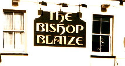
| West Gate
The site of the old West Gate which was fairly
unimpressive is marked by a plaque on part of the city wall. The gate was
demolished in 1815. Cross back over the road and hopefully you'll find
some steps leading down to the back of the Bishops
Blaize. This is the final stop of this mammoth
crawl. The pub is in an area known as Shilhay and has been called Nosey
Parkers in the past. It was a disco pub in the eighties, thankfully its
now reverted back to being a pub.
The name Shilhay comes from 'shill',
which was a shelf or a ledge and 'hay' meaning fenced or enclosed. In its
prime Shilhay was a flat piece of land just above river level criss-crossed
by leats which drained the land and drove water wheels as described previously
at Exe Island.
|
|
Bishops Blaize was the patron saint
of the wool trade, for which this area of land was primarily used reaching
a zenith between 1670 and 1720. The Bishop was flayed using a Woolcombers rake.
The Inn dates from 1327 and was the first to be opened outside the City Walls. It
was originally a meeting place for the wool
people; Tuckers, Weavers and Shearers before Tuckers Hall
was built in 1471.
The nearby residential scheme now provides another clue to this with names like Teazle, Weavers, Dyers and Carders Court. This area was once covered with cloth drying racks. The council built this housing scheme in 1982 despite intense lobbying for a sports centre / outdoor activity centre. A terrible missed opportunity. The scheme though does compliment the area and won design awards. Strangely enough the residents constantly complain about the noise generated by the nearby nightclubs. |
| Ablaize
Very close to the Bishops Blaize was Cricklepit Mill after
which the new suspension bridge over the river is named. This old mill was to be renovated and developed by the council until
it was burned down on 28th March 1999.
The mill was built in 1190, one of two licenced for grinding wheat, the dry house
is C18th and was used to dry cloth from the fulling mills undercover. The cloth was
stretched tight on beams from 'tenter-hooks'. The fire was most likely started inadvertantly by vagrants in an attempt to keep warm.
That's it, enjoy tomorrow's hangover!
Stuart Callon Copyright ©2001, 2002, 2003, 2005, 2008 |
 |