 EXETER
Through the bottom of your
beer glass
Exe Crossing
EXETER
Through the bottom of your
beer glass
Exe Crossing
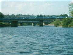
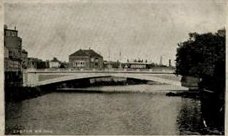
 The two bridges that you now see crossing the Exe were today were completed in 1974 (the north bridge in 1969).
Much controversy surrounded the building of the two modern bridges, reorganising the the riverside on both sides of the
river. Western Way was also constructed to link with the new bridges and much of old Exeter was lost in the process. The
damage to Exeter's heritage by the building of these traffic schemes was and is comparable to the damage done by the
Luftwwaffe and demonstrates well how difficult it can be to plan within historical urban areas.
Without these two ugly bridges and the inner by-pass, Exeter would grind to a halt. With them the traffic flows
relatively smoothly and it hasn't taken long for us to forget what was demolished to make way for these schemes.
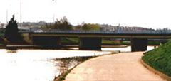
The two bridges that you now see crossing the Exe were today were completed in 1974 (the north bridge in 1969).
Much controversy surrounded the building of the two modern bridges, reorganising the the riverside on both sides of the
river. Western Way was also constructed to link with the new bridges and much of old Exeter was lost in the process. The
damage to Exeter's heritage by the building of these traffic schemes was and is comparable to the damage done by the
Luftwwaffe and demonstrates well how difficult it can be to plan within historical urban areas.
Without these two ugly bridges and the inner by-pass, Exeter would grind to a halt. With them the traffic flows
relatively smoothly and it hasn't taken long for us to forget what was demolished to make way for these schemes.
Flooding during the 1960's was also a major argument for the construction of these two bridges, the piers are designed like the bow of a ship in order to aid water flow.
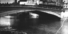
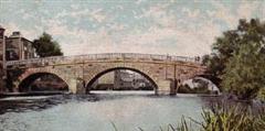
These bridges replaced the former single span steel structure opened in 1905, its old lamp stands can be seen marking the Butts ferry crossing on the Quay and also in Piazza Terracina. The bridge cost 25,000 GBP and was based on and engineering concept known as the "three hinged arch", and was designed by Sir John Wolfe Barry.
In 1901, the citizens of Exeter elected for Electric Trams rather than motor buses. The previous three arched bridge was not able to accomodate tramlines and so a new bridge had to be built. The tramlines were laid into St Thomas and Alphington. The bridge though did tend to act a little like a dam and after serious flooding in the 1960's, the bridge was eventually replaced.
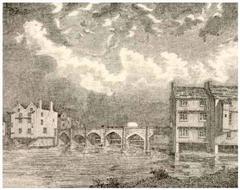
A three arched bridge existed prior to this one. Construction was started in 1770, but floods caused extensive damage and it was not completed until much later in 1778. Flood waters actually washed away part of the bridge during construction. New Bridge Street is an extension of Fore Street and was built to link to the 1778 bridge. An arch which is now defunct can still be seen under the present New Bridge Street. Arches were required to enable the raised street to cross Higher and Lower Leats as well as Frog Street.This bridge replaced the medeival bridge, part of which can still be seen at the bottom of Western Way. Work began in 1770 with Joseph Dixon given the job of linking Fore Street with Cowick Street.
 Before the C9th, Exe Island was mud flats, grass and reeds, the area was ripe for development. Nicholas Gervase
obtained grants to build mills and leats in the area. His son Walter became mayor and between them they raised
money to build Exeter's first stone bridge. Construction was started in 1190 and had a total of 18 arches with
chapels at either end. This narrow bridge enabled farmers to drive their animals to market in Exeter and allow
the mills and industries on Exe Island to prosper. Passing places were built in at each pier. The bridge was
finally completed in 1238 and was completely overhauled in 1449 The bridge also had buildings and houses along
its route in order to provide an income for bridge maintenance.
Before the C9th, Exe Island was mud flats, grass and reeds, the area was ripe for development. Nicholas Gervase
obtained grants to build mills and leats in the area. His son Walter became mayor and between them they raised
money to build Exeter's first stone bridge. Construction was started in 1190 and had a total of 18 arches with
chapels at either end. This narrow bridge enabled farmers to drive their animals to market in Exeter and allow
the mills and industries on Exe Island to prosper. Passing places were built in at each pier. The bridge was
finally completed in 1238 and was completely overhauled in 1449 The bridge also had buildings and houses along
its route in order to provide an income for bridge maintenance.
The remains of a Church dedicated to St Edmund (849-870) can still be seen today on the eastern side of the structure. St Edmund was a King whose shrine at Bury St Edmunds and is famous all over Europe.
Many bridge chapels are in fact dedicated to this saint because after getting beaten by the Danes at Hoxne, King Edmund the Martyr hid under a bridge. When he was eventually found he died a slow painful death for not refuting christianity.
This fact gives rise to the belief that there probably was a church on this site in Saxon times on top of an original Roman Bridge. The bridge currently seen here passed diagonally from St Thomas and led up to the West Gate of the City by Stepcote Hill. It was about four times longer than the present Exe bridges, don't forget that the river was much wider and shallower in those days because it was not constrained by man-made banks.The church only became redundant in the 1960's when Western Way was built, it was made safe and left as a memorial of past times. 1832 saw the church undergo major changes after being burned down, with road widening taking place in 1854.
There was a footbridge in C12th with other traffic fording the river. It was much wider and shallower than today but still was prone to washing animals and humans away.
See also Exe Island. Flooding, Countess Wear Bridges and Other Exe Bridges
If you got to this page by way of Search Engine, please move onto
Stuart Callon Copyright ©2002, 2003