 EXETER
Through the bottom of your
beer glass
Floods & Flooding
The floodplain of the Exe is about 750m wide at Exeter. Excavations in Okehampton St and other places in St Thomas
have indicated that the main river channel occupied the Exeter side of the floodplain from the C1st. When the medieval
Exe Bridge was built around 1200 AD, the river lay closer to Exeter than it does today and Exe Island was considerably
smaller. No habitation was possible back then and the surface of Exe Island consisted of shingle banks overlain with annual
floodwater sediment (sands & silts). The Bonhay part of Exe Island increased rapidly in size after 1200 AD. Riverside walls
were placed around St Edmunds Church (on the Exeter side of the medieval bridge) in order to revet land recently reclaimed
from the river. Plots were created for tennements on Frog St (now the inner by-pass). The reclaiming of this land and
construction of the bridge resulted in increased alluvial deposition on the inside bend of Bonhay. The accretion on Exe
Island was accompanied by erosion of the outer bend of the river cutting into the floodplain and hence the river shifted
westwards towards St Thomas until the C18th.
EXETER
Through the bottom of your
beer glass
Floods & Flooding
The floodplain of the Exe is about 750m wide at Exeter. Excavations in Okehampton St and other places in St Thomas
have indicated that the main river channel occupied the Exeter side of the floodplain from the C1st. When the medieval
Exe Bridge was built around 1200 AD, the river lay closer to Exeter than it does today and Exe Island was considerably
smaller. No habitation was possible back then and the surface of Exe Island consisted of shingle banks overlain with annual
floodwater sediment (sands & silts). The Bonhay part of Exe Island increased rapidly in size after 1200 AD. Riverside walls
were placed around St Edmunds Church (on the Exeter side of the medieval bridge) in order to revet land recently reclaimed
from the river. Plots were created for tennements on Frog St (now the inner by-pass). The reclaiming of this land and
construction of the bridge resulted in increased alluvial deposition on the inside bend of Bonhay. The accretion on Exe
Island was accompanied by erosion of the outer bend of the river cutting into the floodplain and hence the river shifted
westwards towards St Thomas until the C18th.
 This resulted in serious flooding in St Thomas over a long period. The C15th saw particularly bad floods
with the first St Thomas Church being washed away in 1412. The church stood on the riverbank at west end of the medieval
bridge. Tennements in the area of Cowick Street were also abandoned at this time.
This resulted in serious flooding in St Thomas over a long period. The C15th saw particularly bad floods
with the first St Thomas Church being washed away in 1412. The church stood on the riverbank at west end of the medieval
bridge. Tennements in the area of Cowick Street were also abandoned at this time.
Experts recommended digging two tunnels 3 1/2 miles long and 30 ft in diameter underneath Exeter or re-design
the river channel. Rather surprisingly the river channel was re-jigged and Exeter was deprived of the world's first
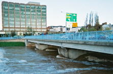
supersonic water flume. A mile long relief channel was dug in 1973 staightening the river and in-filling the leats
upstream of Exe Bridges. Before the scheme was complete though a further torrent in September 1974 demolished Station
Road and washed away the bridge spanning the Exe at the time. Two years later the Army lowered the present river
bridge into position. It was designed to meet any bridge that is or was subsequently built to replace the current
railway level crossing. The new Exe Bridges, cycle and pathways along the river to the Quayside were completed at
around the same time. A further channel downstream of the quay was cut with the overflow just opposite the Port
Royal. A good view of this lower part of the scheme can be had from the Welcome Inn close to the Canal Basin.
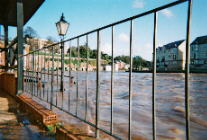
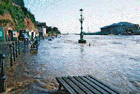
There has been only limited flooding within Exeter since the scheme was completed, although in late 2000 the subways
close to Exe Bridges were full of water, the Quayside was flooded, and the lower bar of the Mill On The Exe was flooded.
Despite this minor flooding, the scheme has obviously been a success, it was opened in September 1977.
Alphington also suffered severe flooding in the 60's but not from the river. In this case it was a feeder stream, the Alphin Brook. The brook was always prone to flooding until it was eventually canalised and diverted from it's natural course in the 1960's after severe flooding in 1960. Flooding from the brook in 1960 went as far as the site on which Sainsburys now stands with flooding from the Exe just about meeting at this point. On 2nd July 1760 a sudden flood from the brook caused more than £1000.00 of damage and completely took out 20 houses. In 1875 several more houses were washed away. There is a concrete wall in the middle of the brook on the bend. This was put in to stop the brook at maximum flow (30mph) spilling over its banks on the bend. A little further on the brook opens into a flood bay 120 ft wide, designed to hold water if the river is in flood and at high tide. Towards the A30 link roundabout is a bank prior to where the brook enters its canalised section. If the water flow here is too great to allow the water into this section, then this bank is designed to act as a dam to stop the village flooding.
Cowley Bridge too has been harmed by catostrophic flooding. Cowley Bridge stands at an ancient crossing point. A bridge is recorded in 1286. Floods in 1809 and 1810 demolished the old stone bridge and the present structure was built in 1813-14, designed by the county surveyor James Green.
See also Countess Wear Bridges and Exe Crossing
If you got to this page by way of Search Engine, please move onto
Stuart Callon Copyright ©2001