|
|
|
| Use the text links for more information! |
|
Go down Richmond Road and You will come out on St David's Hill. Turn Left. The houses on the LHS of St David's Hill were built with no overall plan resulting in a mixture of Victorian styles making St David's Hill a very popular area to live by 1890 with the City close by. Just before you get to the Iron Bridge take the narrow road on the left which runs parallel to the bridge. This is Lower North Street. It will take you beneath the bridge into to Exe Street, you'll be able to have a good look at the bridge from down there. Brewery
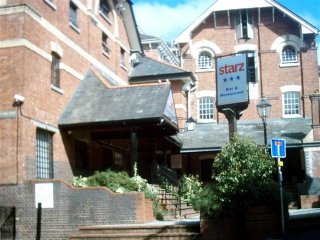
St Annes Well Brewery used to occupy the large building comprising Starz Bar and Restaurant. The building has a poltergeist in the basement, workman working here a few years ago downed tools rather than work a night shift. Large iron bars suddenly started hurtling around, hosepipes whiplashed and footprints inexplicably appeared in the sandy basement floor. There was also the sound of someone supposedly falling to their death. 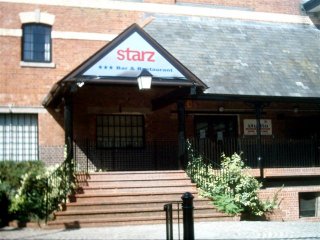
 |
 |
|
|
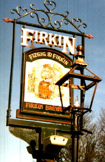
The brewery was developed into a pub in the 1980's and there were
several names including The Fizgig and also The Fizgig and Firkin. Unfortunately the place was shutdown
in late 2001 because of complaints about the noise generated by the live bands.
Starz Bar and Restaurant opened in 2004, there had been talk of converting
the old buiding to flats. Thankfully sense prevailed! Nip in here for a pint.
St Anne's Well Brewery, was built in 1878. Water from St Anne's Well in St Sidwells was piped
into the brewery and this is where the name came from. The brewery was built on the site of the old
stables of the Barnstaple Inn which was burned down in the late 1970's.
Starkey, Knight and Ford took over the brewery in 1960 to brew Whitbread
beer. Genos Restaurant was a former Malthouse for this brewery. It closed in 1966. Brews included
2X, 3X and Home Brew.
The nearby steps leading to Paul Street are far more recent than the Iron Bridge built in 1834 to facilitate access through the North Gate demolished in 1794. These steps were built in the 1970's when Paul Street was widened. |
 |
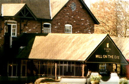 |
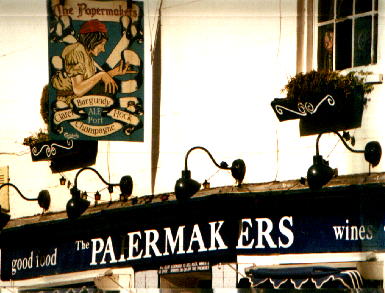
| Exe Island Head off down Exe Street to the Mill On The Exe. Towards the bottom of Exe Street, there was a Mex-Tex restaurant (demolished in 2004). The place used to be the Papermakers (a restaurant- pub) and prior to that, The Papermakers Arms. The name was taken from the former papermaking factory which used to stand close by on the river bank along Bonhay Road. This factory closed in 1967, but the pub had existed since 1820 until 2001. There was a ghost of a former landlord from Edwardian times, 40 years old with bushy hair who ambled along an upstairs corridor and through the wall. I bet he was pissed off when the bulldozers moved in! |
The Mill On The Exe is in an area known as Exe Island. Before the tenth century this was mud flats and reeds, however because of its level situation beneath the city wall which was to the left as you walked down Exe Street along with Bartholomew St. Cemetery Catacombs it attracted the attention of early speculators amongst them Nicholas Gervase. In 1194 he obtained a grant from Robert de Courtney to build a Mill. The Courtneys who were later Earls Of Devon held this land until King Edward VI gave it to the City in 1550. Anyway the Courtneys capitalized on the potential of this marshland using leats to drain the land and levees to raise it sufficiently to dry it out. The Leats were then used to power 20 to 30 waterwheels in the 12th century making Exe Island Exeter's first Industrial Estate. |
| Cattle, Mills and Cholera Until 1939 Exeter's Cattle Market was at Bonhay Road, but is now located on a new site on close to Matford. Also on Bonhay Road was the drinking water extraction pumping station, by a Bridge known as Engine Bridge. Water was originally diverted here from the Exe to power the City's Mills. The leat that ran under the bridge divided in two, Higher Leat and Lower Leat. In 1694 a wooden engine was installed close to the bridge to pump water into the city via a cistern situated at the rear of Guildhall. The Civil War had highlighted the need for a better water supply to the City when the City's underground passages had to be blocked in order to defend the City. The Cholera epidemic of 1832 prompted further improvements and the water engine was finally closed in 1835 with the city drawing water from a newly opened waterworks at Upton Pyne. The water engine was then converted to a wheel driving a grist mill. There were once some cottages here too, Engine Bridge Cottages that have now been demolished. |
|
It has beed told that the Slaughterhouse nearby discharged so much blood into the river that
often the leats ran red and it was fairly common for manhole covers to
be pushed up by the red tide. At the turn of the century, Exe Island was
also a home to the Ice Works, this however was later burned down.
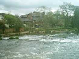
Two foundries competed with each other, Parkin's and Eagle Foundry. Parkin's began in 1897 and they can still be found on Exeter's Marsh Barton Industrial Estate. The company is known as Parkin's Indiustrial Supplies or PIS for short. The Mill On The Exe is located beside Head Weir, above which formed a large pool until the river was later restricted by the recent flood relief schemes, and occupies part of an old paper mill. It was originally a fulling mill for hammering and soaking woollen cloth to felt the fabric, converting to papermaking in 1787. It closed in July 1967 and lay derelict for many years. Much of the mill was demolished in 1982 and the remainder converted into this pub in 1983. |
|
 Food is served upstairs in the lounge bar. On warm sunny evenings or afternoons you can also sit out at the back and watch the river go by. |
|
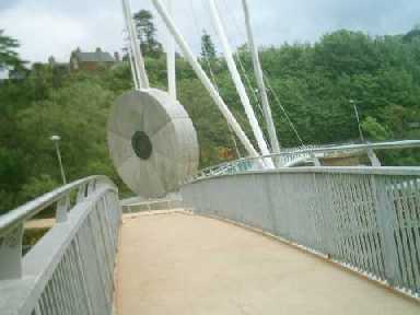
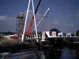
New age of the bike The footbridge / cycle bridge you see spanning the river above the weir was emplaced in September 2002 and is Millers Crossing. Devon County Council has for some time been trying to promote the use of public transport (note all the bus and cycle lanes with millions spent on alternative forms of transport!) This bridge provides easy access to the City for those who live in the Exwick area. Exeter is a hilly City. The Romans built a fort here because it was on a cliff. Difficult access. You know, UP HILL. So why is DCC trying to promote the use of bikes. Are they nuts!? They must be mountain bike lanes. They're green and cost 30% more than the black stuff. Have you ever seen anyone use them? Millers Crossing is illuminated at night and anchored by two 20 metre high tensile steel pylons onto two 6 metre diameter mill wheels, one rises vertically, the other lies flat. |